
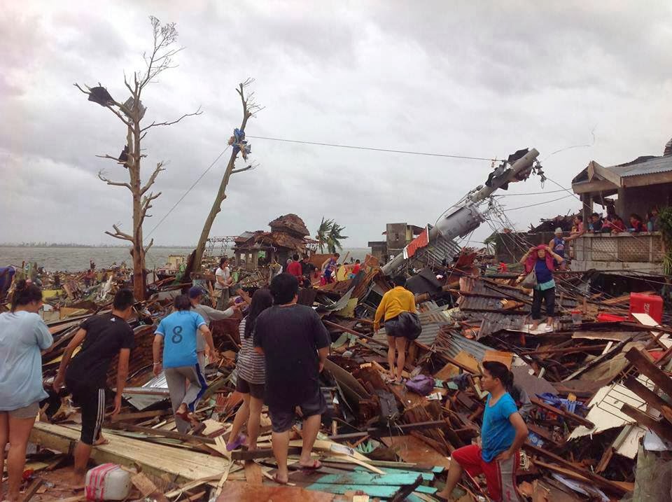
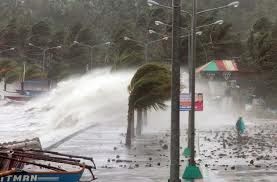
 After the Super Typhoon Haiyan(Yolanda) swept at Tacloban City on November 11, 2013 at the picture.Some of the 2,360 people believed killed in a Philippine city namely Tacloban City by a violent Typhoon Haiyan blow away houses and buildings with the very strong winds and giant waves on November 11 2013. As the scale of the devastation became clear on Sunday from one of the worst storms ever recorded, officials projections the death toll could rise even higher when emergency crews reached the island cut off by floods and landslides. Among the missing are four Canadian from Montreal who was in the country to help build a church. Filipino-Canadians have been raising funds for the church and was in a town called Bungtod located in one of the areas worst hit by Super Typhoon Haiyan with 145mph speed equivalent to 235 km/ h in this country. Super Typhoon Haiyan stronger than hurricanes Katrina on 2004.The packing winds 3.5 times as strong as Hurricane Katrina, pushed in the wall of water 15 feet high and wash away towns in many islands.Moreover, in a country called philippines frequently hit by earthquakes, volcanic explosions and tropical storms, Typhoon Haiyan looked devastating natural disasters to a world record. Intensity is one of the three ingredients that can turn natural disasters into disasters.
 Effects of Typhoon Haiyan (Yolanda) in the All Area Philippines
1.Calabarzon, —Dead= 3—Injured=4—Missing=0
2.Mimaropa, —Dead=19—Injured=61—Missing=6
3.Bicol Region, —Dead=6—Injured=21—Missing=0
4.Western Visayas, —Dead=250—Injured=464—Missing=22
5.Central Visayas, —Dead=74—Injued=348—Missing=5
6.Eastern Visayas, —Dead=5,715—Injured=26,766—Missing=1,726
7.Zamboanga Peninsula,—Dead=1—Injured=1—Missing=0
8.Caraga, —Dead=1—Injured=0—Missing=0
Total, —Dead=6,069—Injured=27,665—Missing=1,779
Satellite Imagery Super Typhoon Haiyan(Yolanda)
Source of picture:WRNOB
Track storm and Satellite Imagery
source of picture:WRNOB |
Animated Super Typhoon Haiyan(Yolanda)
_making_landfall_on_Leyte_Island.gif)
Source Of Pictures:Pagasa
Super Typhoon Haiyan(Yolanda) animated

source of Pictures:Noaa
Typhoon Haiyan related to climate change
Both political leaders and climate center has been connecting typhoon to climate change. The climate was consequently published analysis correlating the intensity of storms and increase the speed of the storm as far as the development of global warming . But the collective response still see these events as acts of all the universe, nurturing silence on their possible links to climate change. Therefore, installation of scientific evidence suggests they also serve human relationships. That is, the increasing convergence carbon in the atmosphere is associated with more extreme weather. When the increase in income, good communication, and technology as well, people's ability to endure natural disasters has Improved and face the natural disasters are more challenging. At the same time, the growing population is also increasingly finding in harm's way and become very susceptible to risk. And most of all, increasing the frequency of extreme danger. twice that of a jet aircraft taking off, a Super Typhoon Haiyan considered strong tropical storm in recorded history. The second factor is the exposure of people to danger, as demonstrated by the disproportionate impact on vulnerable populations during heatwaves are dangerous Europe. The main reason is the fear that climate action will slow down economic growth. Many people still view the investment climate as a cost to growth and not yet realize that a lack of action is what will stall do growth. Even when they detect a link, the effect of the delay appears to be occurring only in the distant future or affect many others. But imagine if it was understood that no action will actually worsen climate growth prospects for other countries. The response to this increasing frequency of extreme danger would surely be soon.Super Typhoon Haiyan stronger than hurricanes Katrina on 2004.The packing winds 3.5 times as strong as Hurricane Katrina, pushed in the wall of water 15 feet high and wash away towns in many islands.After the Super Typhoon Haiyan(Yolanda) swept at Tacloban City on November 11, 2013


